
Compare Home Insurance Plans in Ohio
Find your best options in less than 2 minutes


AI-Powered Tools Reshaping Home Insurance Underwriting
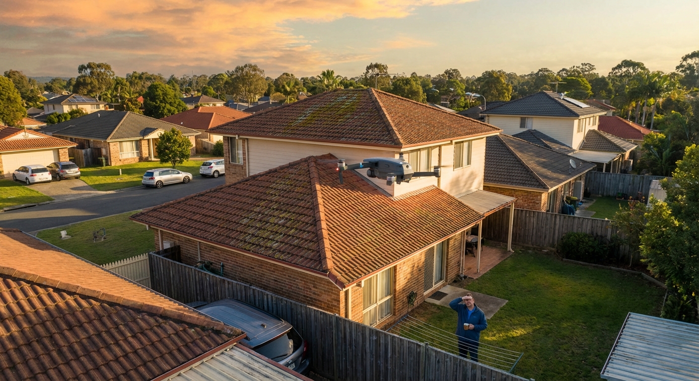
Insurers have quietly deployed some of the most sophisticated technology available to evaluate your home, and most homeowners have no idea it's happening. Satellite platforms, aerial imagery engines, and drone fleets now allow carriers to assess your roof's age and condition, flag hazardous vegetation, identify unpermitted structures, and generate a property-specific risk score, all before a single human inspector ever steps foot on your property.
The leading platforms behind this shift include CAPE Analytics (acquired by Moody's), EagleView, ZestyAI, Nearmap, Tractable, and Verisk. These companies process billions of data points from high-resolution aerial and satellite images using computer vision and machine learning. CAPE's Commercial Property Intelligence provides insurers like The Hartford, Mercury Insurance, and State Auto with aerial imagery-based property intelligence at submission, while ZestyAI's Z-FIRE, Roof Age, and Z-PROPERTY models serve carriers such as Southern Oak Insurance and Lilypad-Centauri. Nearmap advertises that all 10 of the top 10 P&C carriers use its platform for exposure management and claims triage.
What These AI Systems Actually Detect
The data collected during automated assessments goes far beyond a simple roof check. AI and drone imagery are widely used to score roof condition, vegetation proximity, debris, pools, trampolines, and unpermitted structures, with underwriters acting directly on those model outputs. According to Verisk's 2026 U.S. Roof Report, roughly 38% of American residential homes now show moderate-to-poor roof condition based on AI analysis of aerial imagery. Here's a breakdown of what AI systems typically flag during an underwriting scan:
| Category | Examples of Data Collected |
|---|---|
| Roof & Structure | Age, condition, missing shingles, granule loss, mold, moss, water damage |
| Vegetation & Hazards | Overhanging trees, yard debris, brush growth, wildfire fuel loads |
| Property Features | Pools, trampolines, unpermitted structures, outbuildings |
| Environmental Context | Wildfire/hurricane proximity, flood zone, neighborhood crime data |
| Dynamic Monitoring | Pre/post-event comparisons, real-time image updates, claims fraud detection |
Major carriers including Allstate, State Farm, USAA, Farmers, and Liberty Mutual have all established formal protocols for using drone inspection reports in underwriting and claims. In 2026, underwriting is increasingly "continuous," meaning risk scores and premiums update as imagery, weather feeds, and IoT signals change, not just at annual renewal. Learn more about how insurers use these tools during the home insurance underwriting process.
How Predictive Analytics Affects Your Rate
Traditional underwriting relied heavily on your claims history: what happened in the past drove what you'd pay in the future. AI-powered predictive analytics flips that model. Insurers now use forward-looking risk scores built from hundreds of variables per property to estimate what's likely to happen next.
The financial impact is already being felt. Insurify projects that the average annual home insurance cost will rise 4% in 2026 to $3,057 by year-end, after jumping 12% in 2025. That represents a cumulative 46% increase since 2021, with not a single state spared. For high-risk properties (aging roofs, wildfire exposure, or hurricane-zone locations), AI-driven precision pricing can mean increases well above the national average. Learn more about how roof age impacts your coverage options and what to expect in our guide on home insurance rates in 2026.
The broader climate-driven rate environment is amplifying AI's role: as weather-related losses mount, insurers lean harder on precision tools to identify and price out properties they consider too risky to insure.

Compare Home Insurance Plans in Ohio
Find your best options in less than 2 minutes
Benefits of AI Underwriting: The Homeowner Upside
Despite the concerns (covered in the next section), AI-powered underwriting delivers real advantages for many homeowners.
Faster Quotes and Policy Issuance
Automated assessments eliminate the need for scheduled in-person inspections, which can delay policy issuance by days or even weeks. This is especially important during a home purchase with tight closing timelines. See our home insurance inspection guide for what to expect during the assessment process.
More Precise, Fairer Pricing
Broad regional pricing can penalize low-risk homeowners who happen to live near higher-risk neighbors. When AI assesses your specific property, a well-maintained home in a moderate-risk area may actually see lower premiums than under the old model. Options like virtual and satellite-based inspections are also making it easier to bind coverage quickly, and your credit-based insurance score is often blended with property scores for a more nuanced rate.
Better Fraud Detection
Pre- and post-event image comparisons allow insurers to verify that claimed damage actually occurred and is new, rather than pre-existing wear. This helps contain fraudulent claims, which contribute to the premium increases that all policyholders absorb. You can also use this to your advantage by documenting your home's current condition thoroughly before filing a claim.

Protect your home with State Farm
Average Rate:
Homeowners who bundle and save with State Farm save an average of $1,000 per year!

You're in Good Hands® with Allstate
Average Rate:
Get comprehensive home coverage with flexible policy options.

Customize your home coverage
Average Rate:
Only pay for the coverage you need with personalized home insurance.
Smart coverage for your home
Average Rate:
Protect what matters most with award-winning home insurance.
Concerns: Privacy, Rate Hikes & Denied Coverage
Privacy and Lack of Consent
One of the most significant concerns is that insurers commonly conduct drone and satellite assessments without notifying the homeowner. Insurance companies routinely deploy drone imagery and satellite photography to assess the condition of homes they insure, often with no notice to the policyholder. Many homeowners only discover their property was remotely inspected when they receive a demand to repair or a notice of non-renewal.
That is changing quickly. As of mid-2026, several states have moved to regulate the practice:
- California AB 75: Requires admitted insurers to notify residential property policyholders that aerial images may be taken during the policy period, defines aerial image broadly to include aircraft, satellite, and drone-based imagery, requires insurers to provide the images to the policyholder on request, and prohibits basing a coverage-termination decision on an aerial image taken more than 180 days before the notice. New provisions are operative July 1, 2026.
- Hawaii SB 2953 (effective July 1, 2026): No insurer may take an adverse underwriting action on a residential property policy using an aerial image or aerial-image-derived output as the sole basis, and insurers are prohibited from selling, transferring, or sharing aerial images or derived outputs without the consumer's written consent.
- Massachusetts H.1242: Requires nonrenewal notices based on aerial imagery to include date-stamped copies of the images, identify the specific noncompliant conditions, and give homeowners at least 60 days to cure defects before nonrenewal takes effect.
- Colorado Bulletin B-5.57 (March 2026): Requires aerial imagery used for underwriting or rating to be no more than 12 months old, warns that visible conditions should not be the sole basis for adverse actions, and preserves homeowner appeal rights.
- Louisiana R.S. 22:1339: Insurers cannot rely solely on aerial images to justify cancellation or nonrenewal unless the images were taken within 24 months of the policy action.
- Michigan Bulletin 2025-12-INS: Requires insurers using aerial imagery for cancellation or nonrenewal to notify the homeowner, provide copies of the imagery, and allow a challenge or correction.
- Tennessee Bulletin 25-03 (updated April 2, 2026): Directs insurers to treat aerial imagery as one of multiple tools rather than the sole basis for adverse action.
- Georgia SB 409 / HB 1344: Signed May 2026 with a January 2027 effective date, requires date-stamped images no older than 12 months from the notice date.
- Texas HB 2067: Requires insurers to provide the Texas Department of Insurance with quarterly written reports summarizing reasons for declinations, cancellations, and nonrenewals of residential policies, with reporting beginning April 1, 2026.
- NAIC AI Systems Evaluation Tool: The pilot went live in March 2026, runs through September 2026, with formal nationwide adoption expected at the fall meeting in November. Participating states include California, Colorado, Connecticut, Florida, Iowa, Louisiana, Maryland, Pennsylvania, Rhode Island, Vermont, Virginia, and Wisconsin.
Thirteen states have now issued specific aerial imagery bulletins (Alabama, Delaware, Louisiana, Maine, Maryland, Massachusetts, Michigan, New Hampshire, North Carolina, Pennsylvania, Rhode Island, Tennessee, and West Virginia), with more states including Colorado, Connecticut, Georgia, and Iowa moving in the same direction. Learn more about state-by-state home insurance reforms in 2026.
Automated Flags and Non-Renewals
AI systems are programmed to flag specific property conditions, and those flags can have immediate consequences. Consumer advocates including United Policyholders report homeowners being dropped for issues as small as moss on shingles, overhanging branches, or even shadows the AI misidentifies as damage. In Texas, aerial imagery underwriting has become a leading culprit: a carrier's algorithm can flag your roof from satellite imagery and issue a non-renewal before a human ever reviews your file, and Texas homeowners insurance non-renewals surged 269% in one year as satellite and drone screening expanded. Common triggers include:
- Roof age over 15 to 20 years (many carriers have moved the line from 20 down to 15 in 2026)
- Moss, algae, or granule loss on shingles
- Trees overhanging or touching the roof
- Unpermitted structures visible from aerial imagery
- Trampolines or pools without safety features
A flagged property can receive a demand to remediate within 30 to 60 days, a premium increase at renewal, or an outright non-renewal notice. If you've been dropped, understanding why home insurance denials happen can help you find replacement coverage faster.
Algorithmic Bias and Accuracy Concerns
AI models trained on historical underwriting data can inherit the biases embedded in that data. In Huskey v. State Farm, filed as a proposed class action in the Northern District of Illinois in 2022 alleging State Farm's claims-processing algorithms disproportionately burden Black homeowners in violation of the Fair Housing Act, discovery remained ongoing as of the July 2026 status update, with the case still active. Policyholder attorneys expect similar suits to spread to homeowners underwriting, where AI assessments can also simply be wrong by misidentifying an old satellite image, flagging a repaired issue that no longer exists, or miscalculating roof age from low-resolution imagery.
What Homeowners Should Know & How to Prepare
Being proactive is the best defense against AI-driven insurance surprises. Here's a practical action plan.
Step 1: Review Your Policy Documents
Check for clauses related to remote inspections, drone use, and automated property assessment. If your policy is ambiguous, call your insurer and ask directly: "Do you use satellite imagery or drone inspections to assess my property, and how recent is the imagery?" Understanding what happens at policy renewal will help you anticipate when your property is most likely to be rescored.
Step 2: Do a Pre-Inspection Walk of Your Own Property
Walk your property with the eyes of an aerial camera. Look for:
- Visible roof wear, missing shingles, moss, or debris accumulation
- Tree limbs that overhang or touch the roofline
- Gutters that are pulling away, clogged, or visibly damaged
- Yard items that suggest elevated liability (trampolines, unlocked pools)
- Outbuildings or structures that may not appear on your permit history
Also review common home maintenance requirements that insurers now enforce.
Step 3: Document Everything
Take dated photographs of your property's current condition, especially your roof. If you've recently made repairs, keep all contractor invoices and permits. This documentation becomes your evidence if you need to dispute an automated assessment finding.
Step 4: Dispute Inaccurate Assessments
If you receive a non-renewal or rate increase based on an AI assessment you believe is inaccurate:
- Request the specific findings and images used, in writing (many states now require insurers to provide these)
- Hire a licensed roofing contractor or property inspector to conduct an independent assessment
- File a formal appeal with your insurer using your documentation. In most states you have a 60-day window from the notice date to submit a contractor's report proving the image is outdated or incorrect.
- If unresolved, file a complaint with your state's Department of Insurance
- Contact a public adjuster if a claim denial is involved. Our guide on dealing with insurance adjusters walks through negotiation tactics.
Step 5: Shop Around Regularly
Different insurers use different AI platforms and risk models. A property that scores poorly in one insurer's algorithm may be perfectly acceptable to another carrier. Learn how to get accurate home insurance quotes from multiple carriers to find the best fit.
You may also be eligible for discounts that offset some of the AI-driven pricing pressure, particularly for upgrades like impact-resistant roofing, updated electrical systems, and monitored security devices. If you have an older roof, review the 15- to 20-year roof age thresholds that trigger many automated non-renewals.
Frequently Asked Questions
Can my insurance company inspect my home with a drone without telling me?
In most states, yes. Insurers can currently conduct aerial and drone-based property inspections without providing prior notice, and it is standard practice at policy issuance, renewal, and after weather events. However, California (AB 75, operative July 1, 2026), Hawaii (SB 2953), Massachusetts (H.1242), Michigan, Tennessee, Louisiana, and about a dozen other states now require disclosure or limit adverse decisions based solely on aerial imagery. Always review your policy's inspection clauses and ask your insurer directly about their remote assessment practices.
What will an AI or drone inspection flag on my home?
The most commonly flagged items include roof age, condition, and visible damage (missing shingles, moss, granule loss), overhanging or encroaching tree limbs, yard hazards like trampolines and unlocked pools, unpermitted structures visible from the air, and unkempt vegetation that increases fire risk. Verisk's 2026 U.S. Roof Report found that about 38% of American homes now show moderate-to-poor roof condition in AI-scored aerial imagery, so roof issues are by far the most common trigger. Items inside your home are not visible to aerial inspections, so the focus is entirely on exterior and surrounding conditions.
Can I lose my home insurance because of a drone or satellite inspection?
Yes. Insurers have non-renewed and canceled policies based entirely on findings from remote AI assessments, with no in-person inspection. Most states require insurers to give 30 to 60 days notice before a non-renewal takes effect, giving you time to make repairs, appeal, or find new coverage. New state rules in California, Colorado, Hawaii, Massachusetts, Michigan, Tennessee, and Louisiana are increasingly prohibiting adverse actions based solely on aerial imagery.
How do I dispute an AI home insurance assessment I believe is wrong?
Start by requesting the specific findings and any supporting imagery from your insurer in writing. Colorado's Bulletin B-5.57, Michigan's DIFS Bulletin 2025-12-INS, Massachusetts H.1242, and California's AB 75 now guarantee policyholders a meaningful opportunity to dispute imagery-based adverse actions and submit proof of repairs. Obtain an independent inspection from a licensed contractor, compile any receipts for recent work, and submit a formal written appeal. If the insurer does not reverse the decision, file a complaint with your state's Department of Insurance.
Will AI underwriting ultimately make home insurance cheaper or more expensive?
The answer depends heavily on your specific property. Homeowners with newer roofs, well-maintained exteriors, and low-risk locations may benefit from more precise pricing that reduces their premiums. For higher-risk properties (aging roofs, coastal locations, wildfire-prone areas), AI-driven granular pricing typically results in higher rates and stricter coverage terms. Nationally, Insurify projects premiums will rise about 4% in 2026 to $3,057 as AI makes it easier for insurers to identify and charge more for elevated risk.